

32 Mile course description
These directions and distances are estimated.
Course Elevation at the start is 7480 feet.
The 32M course begins just above the head of the DRY FORK aid station and proceeds north and to your left climbing about 500 feet up the 4-wheel drive road. Panoramic views in all directions will greet you as you follow the ridge to RILEY POINT. If you look down to your left you are viewing the Dry Fork Drainage where later you will be joining the 50 mile course for the remainder of the race. At about 6 miles the course drops steeply for a mile into Miller Creek before reaching the COW CAMP aid station, at mile 8.5 and 6600 feet. This is where you join the 52 mile course.
The aid station is fully supplied for the 6 mile gradual climb back to the head of the DRY FORK aid station at mile 13.5 which is a fully stocked station with outhouses. After leaving the aid station the course proceeds up the Freeze Out road, following trails and a gravel road cresting on Camp Creek Ridge at 8,100 feet. It then descends down Sheep Creek drainage to 7450 feet on a four-wheel drive road. After running about 5 Miles from the Dry Fork station will reach the fully supplied UPPER SHEEP CREEK aid station (18.5-mile Checkpoint) . Next is the summit of Horse Creek Ridge at 8,000 feet, following trails and primitive four-wheel drive roads, which will then drop you into Tongue River Canyon. Take a moment to view the canyon and the distant plains before you descend the trail through seas of wildflowers.
LOWER SHEEP CREEK aid station at mile 23.5 and 5025 feet, is a good place to fill your bottles before entering the sometimes hot canyon below. Continuing on to the TONGUE RIVER aid station at mile 25.7 and approximately 4240 feet which is well stocked with food and drinks and outhouses. You will then leave the trail and run on a relatively flat gravel road for the remainder of the distance. At about mile 28.7 is the final aid station, HOMESTRETCH aid station. Continue on and just as you are entering Dayton you will cross the Tongue River on a rustic footbridge. Runners then cross Highway 14 and proceed into town making a left onto 3rd street. Go one block and make a left onto Broadway and into Scott Park where the FINISH and picnic gala await you.
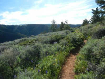
Trail along Riley Point
32 mile aid stations
Bighorn Trail Run Aid Stations are famous in the Trail Running community & are known for extravagant aid station supplies and the best volunteers in the world!! We are taking extra precautions when preparing and serving food and drinks to participants, however, aid stations are remote and require some handling by volunteers and are served outdoors. There are opportunities for drop bags where you can store personal food/drinks to take with you when you come through the aid stations should you forgo provided options.
Riley Point ~ No Cutoff
Mile 5.0 Elevation 8900’ Minimal Aid, No Crew
Kern's Cow Camp ~ No Cutoff
Mile 8.5 Elevation 6600' Moderate Aid, No Crew
Dry Fork ~ 3:00PM Cutoff
Mile 13.5 Elevation 7480' Major Aid, OUTHOUSE, Crew, Medical Check, Drop Bag Station, Official Timing Checkpoint
Upper Sheep Creek ~ 4:30PM Cutoff
Mile 18.5 Elevation 7450' Minimal Aid, No Crew
Lower Sheep Creek ~ No Cutoff
Mile 23.5 Elevation 5025' Minimal Aid, No Crew
Tongue River Trailhead ~ 6:45PM Cutoff
Mile 25.7 Elevation 4240' Moderate Aid, OUTHOUSE, Crew on foot or by BIKE ONLY, Official Timing Checkpoint
Home Stretch ~ No Cutoff
Mile 28.7 Elevation 4040' Minimal Aid, Crew on foot or by BIKE ONLY
SCOTT PARK FINISH ~ 8:00PM Cutoff
Mile 32 Elevation 3970' Major Aid, Drop Bags Allowed
